Brooke Reams
 Brooke Reams is a GIS developer and analyst at Esri, and an instructor at the University of California Riverside Extension. She earned a Bachelor’s degree in Geography from the University of Mary Washington, and a Graduate Certificate in GIS from George Mason University.

What is your role at Esri?
I have two main roles at Esri. The first is to develop Python scripts to automate our customers’ GIS workflows, and the second is to develop custom mobile mapping applications with AppStudio for ArcGIS.
How did you become a guru in Python coding?
I became a Python guru shortly after I began working at Esri. A senior database analyst that I worked with at the time received a Python script from a customer that wasn’t working properly. He sent the code to me and asked me to see if I could find the issue and fix the problem. I had never seen Python code at that time, but I had taken a VBA class in high school, and a couple of C++ classes in college, so I understood basic programming concepts (loops, conditions, etc). I was able to understand the code well enough to both find the problem and fix it. From working on that script I gained a huge interest in Python and developing script tools that automate workflows. I took a couple of Python courses through the Esri Instructor-led training program, and before I knew it, I became the person my colleagues went to when they needed any automation work.
What sort of doors has Python programming opened for you?
It has opened several doors for me. In 2013, I began teaching a 3 credit, elective course in Python as part of the GIS Certificate Program at UCR Extension. This has allowed me to gain experience as a classroom instructor. I’ve also had the opportunity to learn about different fields of work. The industries that GIS crosses are limitless. Performing analysis to find solutions to spatial problems often requires at least a basic understanding of the industry in which GIS analysis is being applied. The same is true when automating GIS workflows with Python. Through my work with various customers, I’ve had the opportunity to learn about so many other fields of work – from health, to utilities, federal government, parks and recreation, and so much more.
Learning Python has also enhanced my ability to learn other development languages. My experience as a Python developer has enabled me to easily pick up other languages/development platforms. The most significant worth noting is mobile app developing with AppStudio for ArcGIS using QML and JavaScript programming languages.
What have been some of your career milestones?
My career milestones have come in the form of technical achievements. The most noteworthy have been:
- Developing a Python script that reduced the amount of time for creating a maritime chart for navigation from 3+ weeks to 5 minutes
- Developing a Python script that reduced the amount of time for preparing and publishing premium content in ArcGIS Online from several weeks to several seconds
- Developing three mobile apps published to the AppStore and Google Play
Those are some excellent accomplishments! Can you tell me more about the mobile apps you developed for the App Store?
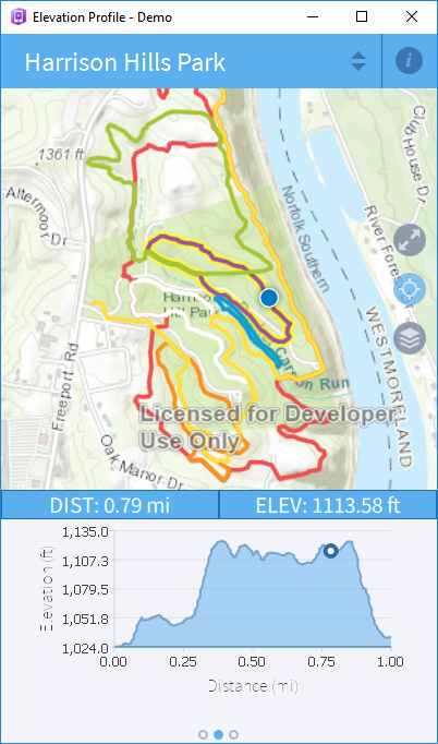
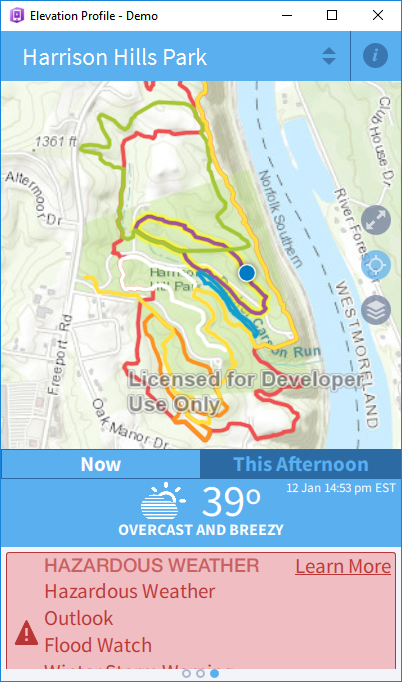
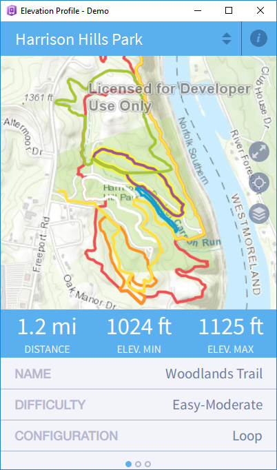
One of them is an app that I developed for the for the Allegheny County Parks and Rec department in PA. The app allows users to select a hiking trail from the map and shows basic information about the trail – difficulty level, blaze color, distance, minimum and maximum elevation, etc. The app also shows an elevation profile of the trail where the x axis is the distance (m value), and the y axis is the trail elevation (z value). With the trail selected, the app detects if the user’s current GPS position is along the trail. If it is, the app uses a marker on the graph to show the user where they currently are along the elevation profile. Additionally, the app also shows the current and forecasted weather conditions for the County.
What gets you most excited about coding?
Coding gives you instant gratification. You make a change, enhancement, or fix to your code, you run it, and you can see the results right away. There’s no waiting around. It does exactly what you tell it to do, and if you’ve written your code correctly, it’s gratifying to see it run. It also gives a sense of achievement. It can be challenging and sometimes even frustrating when trying to figure out how to write code to get a piece of functionality working the way you want, or when trying to fix a bug that’s causing your app/program to give unexpected results. The achievement you feel when you finally get a bug fixed or some difficult functionality working is extremely rewarding.
Who are your role models and how have they inspired you?
Jack Dangermond is definitely one of my biggest role models. His love and passion for solving the world’s spatial problems is contagious. It’s inspiring to listen to him talk about GIS and the good that it can do. From his philanthropic contributions, you can tell that to him, Esri is more than just a company he started to make money. It’s a means for making the world a better and safer place, and preserving its natural beauty. It’s easy to be proud of the company that you work for when its leader is real and genuine.
Have you faced any challenges with being a woman in tech and if so, what have those challenges been?
Fortunately, I have not faced any challenges with being a woman in tech that I can recall. Throughout my tenure at Esri, I’ve always felt like my voice has been heard, and that my colleagues trust the quality of my work. I have a manager who constantly lifts me up, constantly considers me for new opportunities, and greatly respects me as an employee. I’ve been very fortunate to have this experience – I know that not all women do.
What is your best advice to women looking to advance their careers in GIS?
Find something you are passionate about and become the expert on it. It’s so much easier to be good at what you do when you actually like (and even love) what it is you’re doing. It could be a specific industry – Utilities, Public Safety, Natural Resources, etc – or it could be a certain application/programming language – WebApp Builder, GeoEvent, Python, JavaScript, etc. Put in the extra effort to learn as much as possible and get good at what you do. Be confident. Don’t be afraid to speak up in meetings when you have an idea or a difference of opinion. Don’t be afraid to ask questions when you don’t understand something. And DON’T be afraid to ask for a promotion or raise when you feel like you truly deserve one.
Interview conducted by Kelsey Kaszas with Epic Land Solutions, Inc.