Jennifer Schottke
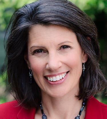 Jennifer Schottke is an Advocate for Spatial Technology applied to Community Risk Reduction. She has over 15 years of experience dedicated to community development at the crossroads of fire/rescue services, public safety, media and technology. Jennifer spent 18 years as the Esri lead for fire/rescue GIS and developed an annually updated Esri’s strategic marketing plan to advance fire/rescue GIS. Among many of her accomplishments while at Esri she advocated for and supported the development of the ArcGIS solutions for fire. Created “Fire GIS University”, a week-long training event to teach key geospatial analysis skills required by fire and emergency service agencies. She has also envisioned and facilitated the creation of the National Alliance for Public Safety GIS (NAPSG); Established a national network of ten regional fire GIS user groups which have evolved into the existing NAPSG Foundation Regional Leadership Teams and an informal network of thousands of public safety GIS professionals and advocates. And spearheaded the creation of the National Fire Protection Association (NFPA) Information Technology Standards Committee.
Let’s meet Jennifer!
Q. When did you first discover GIS and what got your career started?
A. I discovered GIS in a forestry magazine – it was 1993, and I still remember the day I read the article. I had this instant connection with the technology; and a strong intuitive sense of how powerful it would be to add spatial attributes to data I’d been working with on soils, trees and various ecosystem interactions. It was in the early days of desktop GIS and I immediately downloaded a free version of ArcView and ran through the tutorial. I was hooked!
Starting a career can be tough. For me, it took a long time, and a lot of patience, for the various disparate threads of education, experience and interests to come together. Early on I kissed more than a few frog-jobs and experienced a lot of frustration and feeling stuck. I realize now that faith and persistence were key for me. Learning how to pay attention to what I care about and to appreciate what I do well were really important skills to develop as well. But I also know that every once in a rare while, opportunity can drop into your lap. The GIS article in that forestry magazine was one of those moments. Patience, and not giving up on myself paid off. I have been very fortunate to find work that I truly love.
Q. As an advocate for spatial technology in community risk reduction what does that entail?
A. Community Risk Reduction (CRR) is a holistic approach to keeping communities’ safe by reducing the number and severity of emergency incidents. It consists of five elements, which we refer to as the five “E’s”: education, engineering/technology, economic incentives, enforcement, and emergency response. The basic idea is to “get ahead of the problem” by using all five of these strategies to address the root cause of persistent avoidable problems, and/or prepare for likely unavoidable emergencies.
Shifting an emergency response organization’s culture to think about problems before they happen includes helping all personnel start asking good questions such as: Do we know about what’s been happening out in the community? What do others know that might help us protect the community better? How do we put these data together in a way that it can help us discover disruptable patterns? How can we work with the members of the community to influence the occurrence and outcome of potentially hazardous circumstances? What strategies can be appropriately and effectively applied to help reduce or mitigate these problems?
Good data presented in digestible ways helps people identify problems and find creative solutions. Because human influence on emergency events can be complex, spatial data is ideally suited to this problem set. Because many people love maps, and because spatial data can be so illuminating when analyzed well and presented clearly, it is a powerful tool in the CRR toolbox.
 Q. What keeps you motivated in the work you do every day?
A. Two things: 1. The energy of people totally committed to the vision of good data and safer communities; 2. Knowing that something I do or say might actually help someone live a better, longer life.
Q. As a woman, what challenges did you face in the field of GIS and Public Safety?
A. I grew up surrounded by brothers and male cousins, so in some ways working in male dominated environments has come naturally to me. But I think that has also caused me to have some delayed reactions to the inevitable biases I expect most of us face.
Sometimes it’s actually funny how those biases play out. My favorite example is people assuming that I know things I don’t and that I don’t know things I do. People who don’t understand GIS tend to assume that because I do understand it, I can do “all that mapping stuff”. When I don’t have a technical skill to solve someone’s problem I have at times felt judged more harshly than I expect a man would be. On the other hand, I don’t look like a firefighter, but I do know a lot about the fire service. I think I’ve experienced at least 3 lifetimes worth of man-splaining about some pretty basic fire service topics. Early on it was annoying, but I’ve learned how to deal with it. I can usually just take it in stride, and sometimes I can actually use it to my advantage. That’s the good part. The not so good part has been trying to find my voice when I have something important to say and there are no ears to hear. Or being passed-over for promotional opportunities when I felt ready for the challenge.
For most of my career I ignored and pushed back on feelings that a sexist environment was somehow influencing my ability to achieve my goals. I tended to assume that if I didn’t get the promotion or if a man in a position of power was making me feel uncomfortable in our relationship, then I needed to work better, harder or be clearer in my intentions. “My mom always told me life is not supposed to be fair. While I get that, I’ve also come to believe that some unfairness does not have to be tolerated.”
I’ve never been a “me too” victim but I know far too many women who have. Sexual abuse, harassment, inequitable pay, poor working conditions: these are all untenable and are often the result of gender, racial or ethnic bias. I have come to appreciate how much courage it takes to be honest, with myself and others about how bias and inappropriate behaviors impact all of us. And I think the “me too” movement has exposed how many of us have experienced the tendency to blame ourselves first for untenable circumstances we neither cause nor control.
I’ve been fortunate, both in my career and in my personal life, to have incredibly strong support from good, well intentioned men. But still, I have experienced what I now realize has been unfair bias. My inclination to internalize the cause of the biases I have faced has kept me from speaking up or leaving untenable situations sooner. Intolerable situations are just that, and its ok to speak out or remove oneself from that situation if that’s possible.
Q. What project have you worked on that you are most proud of?
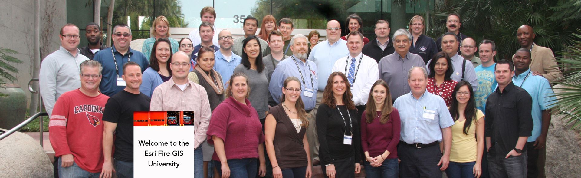
A. Fire GIS University. This was a week-long training event in January 2015. I have always maintained that when fire departments see what GIS can for them they become hooked. When GIS professionals know how to apply appropriate analytics to fire department data, great things can happen. This training brought 60 analysts in from fire departments around the country and took them through a week long intensive training course. It was great fun to watch what they were able to accomplish when they got back home. I love both the technical and the interpersonal aspects of bringing people together to share knowledge and experiences.
Q. What’s your favorite GIS tool or app?
A. If I can have 2, I’d say 1. ArcGIS Online – I still hold out hope that it can become a more widely recognized tool for helping fire departments get better at using data to target problem spots where they can focus more energy and resource. 2. The Esri local government fire GIS tools. I’m totally biased on this one, but I’m really proud of what we were able to do with these templates – I feel like they helped open the dialog between fire people and GIS professionals – and that dialog is an important element of safe communities.
Q. What do you like to do for fun?
A. Travel, swim-run-bike, sew and read.
I love to travel – learning about new places, especially the people and their history. I am fascinated by social geography and how landscapes have shaped the stories of people and places.
I can get obsessed with sewing, and I wish I could be more obsessed with exercising, but I do at least enjoy it.
I also love to read, my most recent trend has been biographies, especially civil war era. In my angst over the resurfacing of our racial discords I find myself wanting to better understand how we got here.
Q. Do you have any advice for young women in GIS looking to excel in their careers?
A. First and foremost: Believe in yourself, follow your passions, and don’t let others tell you who you are and what you should do with your life. If you have a gift or special joy in something, be patient while the right path unfolds so that you can pursue your dreams. Surround yourself with supportive women AND men – and if you don’t have them in your life now – seek them out with intention. The world is full of good people who want to help you seek the opportunity to achieve your goals. Last but not least, be kind to yourself and others – refuse to let the tough parts of life destroy your ability to love.
A big thank you to Ms. Schottke for spending time with WiGIS and providing such inspirational advice!
Interview conducted by Sandra Chakra, Cartographer at Geoprints.