2024-25 Board of Directors |
Officers |
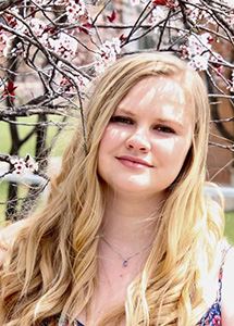
| Wanmei Liang, PresidentWanmei Liang works at NASA Earth Observatory as a Science Data Visualizer, specializing in cartography, science communication, GIS, and remote sensing to produce maps and satellite imagery for NASA's Image of the Day. Beyond her professional role, Wanmei is a passionate advocate for promoting diversity and inclusion in the geospatial field, particularly through her commitment to Women in GIS. Since August 2022, she has been a consistent presence at every Communities of Practice, Mugs and Mornings, and virtual gatherings across all chapters. In addition to her involvement in Women in GIS, she engages with a global audience through her active online presence, in which she shares her geospatial journey and cartography skills. Wanmei is honored to continue her journey with Women in GIS as Vice President, driving the organization's expansion and inclusivity. With her passion, experience, and dedication, she is committed to empowering others and shaping a vibrant future for Women in GIS. |

Vacant, Vice President |
| Samantha Dinning, Past PresidentSam began attending events through the Arizona Chapter in 2020 and became an active member of Women in GIS in 2021. She participated as a mentee which led to being involved in the Outreach & Map Committees, and WiGIS events. She co-founded the Colorado Chapter in 2022. Sam was selected to the 2023-25 cohort of the URISA Vanguard Cabinet, an advisory board of passionate young geospatial professionals; and has an MS in Applied Geospatial Sciences from Northern Arizona University. “I love serving others and working hard to improve my community. I ran for VP of WiGIS because I want to help improve opportunities for women working in geospatial sciences. I am so honored to have been elected to this role and I cannot wait to learn more and help our community!” |
Vacant, Secretary
|
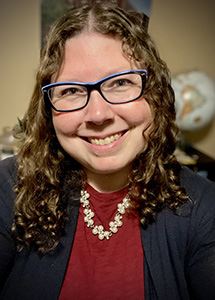
| Elizabeth Houser, Treasurer
Beth Houser has been a GIS professional since 2007. She earned a BS in Environmental Science and a MS from UPenn in Urban Spatial Analytics, focusing on land use and planning. Beth began her career at a regional planning commission, and since 2009, has been the GIS Specialist at WRT, a planning and architecture firm. Working to design communities to be more resilient and equitable, she gets the opportunity to analyze and portray data at differing scales across the US. She served for four years as Treasurer for the Chester County Mothers of Multiples club and is excited to be able to serve the WiGIS community in a similar capacity. During Beth’s “spare” time, she enjoys spending time with her four children, reading, playing board games, gardening, and camping.
|
Committee Chairs |
| Awards & Scholarship: Devika JainDevika Jain is a Data Science Manager at the Center for Geographic Analysis (CGA), Harvard |

| Chapters: Jennifer Parmeley
Jen Parmeley, GISP, is a geospatial advocate with over 20 years of experience in GIS and geographic education. She joined Women in GIS in 2022 on a whim and it was love at first COP meeting. She's built an informal Nebraska chapter of Women in GIS to bring this support to her local community and is so excited to be filling in as Interim Chapters Chair. Experience Builder days are her favorite days at work, Arcade might be her love language, and she is a firm believer in Metadata Mondays (and topology!). In her free time you can find her knitting and chatting in the Crafts & Chats meetups.
|

| External Engagement: Susan Muleme KasumbaSusan has over 25 years of experience in the geospatial industry and is currently the Director of Business Development at Forsite, formerly Barr GeoSpatial Solutions, where she specializes in creating LiDAR solutions for clients across government, engineering, utilities, renewable energy, mining, and forestry. A graduate of Sir Sandford Fleming’s GIS/Cartography program and an attendee of the University of Guelph, she began her career in GIS software technical support, cartography, and photogrammetric mapping before transitioning into sales and business development.
Beyond her professional work, Susan is dedicated to mentoring and industry advocacy. She served for 10 years on the board of BeSpatial Ontario, launching a mentorship program as President to support new professionals entering the field.
As Chair of External Partnerships, she actively connects with industry partners and sponsors to maximize engagement and value for our members. |

| Internal Affairs: Jennifer ZumbadoJennifer Zumbado-Hannibal, GISP, is a Geographic Information Systems Professional with over 20 years of experience in geospatial data management and GIS technology implementation. She serves as the Geographic Information Systems Coordinator for the City of Forest Grove, Oregon. Her expertise includes designing enterprise-level geospatial databases, developing GIS web applications, and automating workflows with Python. A collaborator in Washington County's GIS Infrastructure Group, she has helped standardize data protocols and secured funding for aerial photography and LIDAR missions to support infrastructure and disaster response planning. Jennifer holds a Master of Science in Environmental Sciences and a Bachelor of Science in Geography from Florida Atlantic University, specializing in GIS and Remote Sensing. She is fluent in Spanish and actively participates in GIS organizations, including serving on the board of ORURISA (2019-2021). Jennifer is passionate about diversity and inclusion in GIS, particularly advocating for neurodivergent representation. Her commitment to collaboration, innovation, and diversity in the GIS community is evident throughout her career. |

| Mentorship: An-Min WuAn-Min Wu, Ph.D., GISP, is Assistant Professor of Spatial Sciences at the University of Southern California (USC). An-Min teaches geospatial information science and technology, and her research of interest is in the intersection of socioeconomic development and environmental sustainability. Her research focuses on understanding spatial dynamics of environmental pollution and climate change to inform sustainability and health impacts and their implications of environmental disparity and injustice. An-Min is a faculty cluster lead for M.S. in Spatial Economics and Data Analysis, a faculty co-director for the online Master of Public Health – GeoHealth track, and a mentor for the USC Environmental Health Center’s EH MATTERS fellowship program where she supervises under-representative students on environmental health research. Wu has been actively involved in both faculty governance and professional communities. She previous served on USC Academic Senate and Dornsife Faculty Council, American Association of Geographers (AAG) Specialty Group Human Dimension for Global Change (HDGC) board, and was a past president for California Geographic Information Association. She currently co-leads Women Network at the Association of Pacific Coast Geographers (APCG) and is looking forward to working with the dynamic team in Women in GIS (WiGIS) to support women for their professional career development. |

| Outreach: Jami DennisJami Dennis, GISP, has over twenty-five years of experience in GIS, socio-economic research, demographic studies, data analysis, and data visualization. She has worked in both state and regional government. She now owns her own firm, Geodetic Analysis LLC, where she works on GIS, data analysis, and data visualization projects. She is co-founder of the Arizona Chapter of Women in GIS and has served on the WiGIS Outreach Committee for over 6 years. Jami is passionate about giving back to the GIS community that has given her so much throughout her career. |

| Professional Development: Rupsa Roy
I'm a Senior Project Scientist using GIS, data science, and climate modeling to support
resilience, equity, and sustainability. I work with communities on urban heat, flooding, and environmental justice. I'm passionate about mentoring women in STEM, data storytelling, and inclusive growth. I'm excited to bring my skills and leadership to Women in GIS and help empower others through professional development. I’m passionate about creating inclusive spaces where women in GIS can grow, lead, and thrive. I bring over a decade of experience using geospatial tools to address climate resilience, equity, and sustainability. I’ve led collaborative projects with communities and agencies, and I’m committed to mentoring and uplifting others in our field. I would bring strong leadership, technical expertise, and a deep dedication to empowering diverse voices through professional development. |
